
Introduction
Known as the ‘Snake Mountain’, the Nag Tibba trek begins northeast of Mussoorie at the base of the Garhwal Himalayas at an altitude of 3,048 meters. Locals have been offering prayers (puja) to the serpent god (Nag Devta) at this peak. This is a testament to his holiness. They believe that the snake god protects livestock from snake bites. The
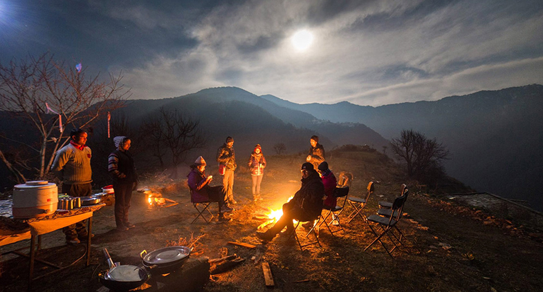
Mussoorie-Nag Tibba Trek will delight any hiker, amateur or seasoned. For visitors from Delhi, it is an idyllic and ideal weekend trek. Trekking offers visitors the opportunity to enjoy a range of mesmerizing experiences, from visions of majestic snow-capped mountains to camping under the stars, to hiking in lush forests.
Nag Tiba trek starts from Pantwari village via Mussoorie Hill Station. There are many charming small villages around Pantwali such as Bansari Village, Kori Village. From Pantwali to the top of Nag Tibah is 8 km. Trekkers trek through ancient forests teeming with toads and oak trees that are home to exotic wildlife. This is a hike of a lifetime for both the adrenaline-seeking adventurer and the more peaceful, nature-loving hiker.
Highlights of our Nag Tibba Trek trip
• Climb Nag Tibba Peak.
• Stunning views of peaks such as Nanda Devi, Bunderpunch and Chaukhamba
• Full of adventure activities
• Picturesque villages in secluded Uttarakhand
• Hotels / guesthouses / tent accommodation
• Beautiful meadows, stunning Beautiful scenery, nice walks through Deodar, oak, and pine forests.
Best Travel Times for the Nag Tibba Trek
The best travel times for the Nag Tibba Trek are in the summer months from April to June and in the winter months from October to December. January to March is the best time to travel to Nag Tibba for travelers who want to experience snowfall and snow trekking in Chopta.
In Summers:
Summers in Nag Tibba are comfortable and healthy. The Himalayas can be seen far away. There is always a cool breeze blowing to calm you down. It is recommended to bring light woolen clothes in case the nights get cold.
In Monsoons
The lush greenery of Nag Tibba during the monsoon season is captivating. There’s
nothing quite like watching the snow-capped peaks of Nag Tibba sip your tea while the raindrops dance around you. Mudslides can block roads for hours, but Nag Tiva’s scenic beauty is worth every effort. Of course, don’t forget your raincoat!
In Winters:
If you’re looking for tranquility and peaceful solitude, you can’t go wrong with the Nag Tibba Trek in winter. Although it snows in the winter, the scenery of Nag Tibba in winter is unparalleled. Naghi Tibba’s winters are frigid, so don’t forget to bring thick wool.
Where nag tibba located
Nag Tibba lies in the foothills of the Garhwal Himalayas, northeast of Mussoorie. The summit is 3048 meters above sea level. It has long been believed to be the abode of the serpent god or ‘Nag Devta’. Local villagers regularly make their way to the top to pray to the snake gods to protect their livestock from being bitten by snakes. The place is visited by hikers and adventure seekers for its panoramic beauty and high altitude. From Nag Tibah, trekkers can enjoy spectacular views of various peaks such as Bandarpanch Peak, Gangotri Peak, Kedarnath Peak to the north, Doon Valley, and snow-capped Chanabang Peak. Nag Tibba is also called Serpent’s Peak. At 9915 feet high, it is the highest peak of the Nag Tiba range in the Garhwal Himalayas.
Detail Itinerary
Day 1
Arrive at Pantwari and trek to Khatian
Distance traveled: 100 km |Time required: 2-3 hours
Hiking distance: 5.2 km |Hiking time: 4-5 hours |Ascent: from 4652 feet 7506 ft | Indiahikes Trekker Pickup Point: Grand Legacy Hotel Lalpul, Dehradun
About 3 hours drive. Slightly moderate increase for the day. A gentle climb along the entire length of cobblestones was maintained by the Forest Service. The trail has long patches of loose stone.
Day 2
Descend to Pantwali and drive to Dehradun Trek
Distance: 9.3 km | Hike time: 5-6 hours | Altitude gains and losses: 7506ft to 9806ft Calm day, 1 hour leisurely ride to Nag Tibba base A climb followed by a steep climb to the summit. Return to Pantwari and return to Dehradun.
Please note: Distance between campsites may vary by 100 meters depending on weather conditions and routes. Elevation can also change by 100 feet for similar reasons.
